Anyone who spends time near New Zealand’s glaciers will have pondered how snow avalanching affects our glaciers. It turns out, the answer is more than anywhere else in the world.
Marin Kneib from ETH in Zurich, Switzerland and colleagues have recently found avalanches contribute 15 % of the snow accumulation to New Zealand’s glaciers. This was the highest contribution for any glacier region of the world.
Most global climate change projections of glaciers ignore avalanche effects. Kneib wanted to know if this mattered or not. As it turns out, Kneib found that for any particular glacier, inclusion of avalanche processes could make a big change to climate change projections, but at the global level the effect was fairly minimal. It seems that the lack of explicit inclusion of avalanche processes is compensated for by adjustment of modelled snowfall. This means that at the large scale everything comes out pretty similar. The conclusion of Kneib’s work is that global projections of glaciers that ignore avalanches are probably OK.
The side effect of the research is that in New Zealand, we can claim top spot for avalanche contributions to glaciers. Well done New Zealand.
Konstantinos Michailos from the Australian National University and co-authors have found that clusters of earthquakes occur near to the Fox Glacier/Te Moeka o Tuawe, Franz Josef Glacier/Ka Roimata o Hine Hukatere, Tasman Glacier/Haupapa and Murchison Glacier/Te Hiwai. What is more, the shallow earthquakes at these locations have seasonal cycles, generally peaking in winter, summer, or both. Digging even deeper, they found that for the Murchison Glacier/Te Hiwai earthquake cluster there was a correlation with high rainfall events. The hypothesis they present for this rainfall-seismicity relationship is that when general strain rates within the basement rocks are high, increased groundwater pore-water pressure caused by large rainfall events can be enough to trigger earthquakes. This is a convincing story, but they also point out that the spatial differences in rock types, groundwater depths, strain rates, glacier dynamics, snow-induced land deformation and monitoring equipment means that the rainfall-earthquake relationship is not clear-cut everywhere. So for the Murchison Glacier/Te Hiwai area it may be reasonable to tack earthquake occurrence onto the end of the weather forecasts. Elsewhere there is still some work to be done before “weather” based earthquake forecasts might be applied.
In a recent calculation of how much ice has been lost from the world’s glaciers, New Zealand’s lack of measurements proved problematic for the researchers. Inés Dussaillant (from the University of Zurich) and colleagues combined manual glacier measurements with satellite glacier elevation data to derive annual changes in glacier mass for each of the glacier regions of the world since 1976. The work assumed a region’s annual glacier mass anomaly could be reasonably estimated from available manual measurements. In New Zealand there are only two glaciers with annual mass measurements, the Brewster and the Rolleston. To beef this up a bit the authors decided to add in data from the Martial Este glacier in the Argentinian part of Tierra Del Fuego. The next problem was that neither the New Zealand or Martial Este measurements extend back very far. To fix that, the study’s authors used the measurement record from Echaurren Norte, a glacier in Chile that has a record going back to 1976. Perhaps it should not be a surprise that New Zealand had the lowest score when the calculations were assessed for robustness by excluding one glacier’s data out of the equation. They removed the Brewster’s data, thereby leaving the Rolleston Glacier and the two South American substitute glaciers as the representatives for the Southern Alps.
Fortunately, the comprehensive assessment has been prepared in such a way that enables re-calculation as new data comes available. So when some additional New Zealand glaciers start being regularly measured, they’ll be able to be used, and the Chilean and Argentinian glacier substitutes will be able to be returned to the bench.
The United Nations declared 2025 as the International Year of Glaciers’ Preservation. It was launched on 21st January. Dr Heather Purdie of the University of Canterbury in collaboration with Dr Brian Anderson of the Victoria University of Wellington provided the first Side Event where they summarised the glacier monitoring efforts occurring in New Zealand. This was followed by a creative “weather report” of the Haupapa/Tasman Glacier.
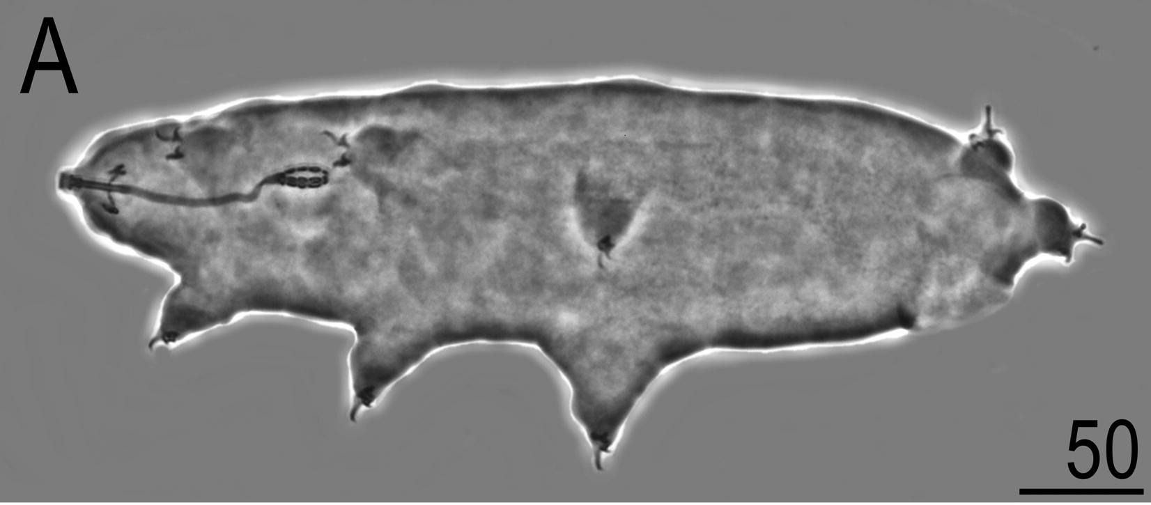
Polish scientist Krzysztof Zawierucha has discovered bears hiding in the snow of New Zealand’s glaciers. More specifically, he and his colleagues have described two new genera of Tardigrades living in the glaciers of the Southern Alps. Tardigrades, also known as water bears, are short fat eight legged animals usually overlooked because they are less than a millimetre long. Tardigrada is a sub classification of the Animalia kingdom (the equivalent sub-classification for humans is called Chordata, then the Mammalia class, the Primate order, the Hominidae family, the Homo genus, and finally the Homo sapiens species).
Krzysztof and colleagues collected snow samples from near the top of the Fox, Franz and Whataroa glaciers. When they melted and filtered out the water and looked at the residue under a microscope, staring right back at them were some Tardigrades (or some equivalent of staring, as they didn’t have eyes). Krzysztof, who is a Tardigrade expert, didn’t recognise the species, or even the genus. After careful consideration of their size and body parts Krzysztof figured out that he was looking at two new genera. One was peculiar for its combination of dark colour, stumpy claws, and big mouth. Krzysztof thought the dark colour could be an adaptation to the high ultra-violet radiation conditions on the snow surface. Similar colouring is found in Tardigrade that live in Central Asian glaciers, so it might be considered an example of parallel evolution. He gave the new genera the name Kopakaius, a latinised version of kōpaka, the Māori word for glacier. He gave the specific species (he only had the one example) the full name Kopakaius nicolae where nicolae is a reference to his wife Nicoletta.
A close-up view of the newly described “water bear” Kopakaius nicolae found in snow on the Fox, Franz and Whataroa glaciers. The scale bar is in micrometres, so the whole bear is about 1 mm long.
The second genera of Tardigrades he called Kararehius, a latinised version of kararehe, the Māori word for animal. This one was transparent and had an unusual combination of stomach sections and claw cuticles. Krzysztof named the species they had collected Kararehius gregorii where gregorii is a reference to his father Grzegorz.
A close-up view of the newly described “water bear” Kararehius gregorii found in snow on the Fox, Franz and Whataroa glaciers. The scale bar is in micrometres, so the whole bear is about 0.5 mm long.
DNA analysis of the bears confirmed their differences from other Tardigrade in the world but the two genera he found were not as different as the body shapes had first indicated. The DNA analysis found that the Kopakaius nicola bears from the Whataroa glacier were genetically distinct from those found on the Fox and Franz Josef glaciers. Krzysztof argues the differences may be associated with the isolation of populations as the previously-connected glaciers have separated into independent units.
Next time you are up in the glaciers, tread carefully and keep a watch out for bears.
The graphs don’t provide a scale on the snow-depth axes, but an average line on the graphs means it is possible to see how the current year’s snow depth is progressing in a relative way.
For reference average peak snow depth at Mueller is about 2.5 m, and at Mahanga and Mt Larkins it is about 70 cm.
Yes it does. And that sound can be used to count, measure and map avalanches. Leighton Watson from the University of Oregon in the USA, with colleagues, has tested a system of using microphone arrays to detect and characterise avalanches falling on to the Milford Road. They installed two sets of “infrasound” sensors near the Homer Tunnel in September 2020. The very next day the Waka Kotahi’s Milford Road Alliance triggered seven large avalanches in the area by dropping explosives from helicopters onto the mountain snow pack. Leighton’s microphones clearly recorded the sound of the avalanches. In fact the sounds were stronger than had been recorded anywhere else in the world. Through cunning trigonometry of the arrival time of the sound at the different microphones, Leighton was able to track and map where the avalanches were occurring. His maps were validated by the observations of the Milford Road Alliance avalanche team. The microphones were left in place for a month and continued to collect avalanche sound data, including naturally occurring night time avalanches. In each case the avalanche location was mapped. Current avalanche risk assessment relies on incomplete avalanche occurrence data, as observation techniques rely on human observation of events or debris. This is problematic in remote regions or during low visibility in storms or at night. Leighton and his colleagues have demonstrated a new approach which could improve avalanche frequency knowledge and make our mountains safer.
Watson, L.M., Carpenter, B., Thompson, K., Johnson, J.B., 2021. Using local infrasound arrays to detect plunging snow avalanches along the Milford Road, New Zealand (Aotearoa). Nat Hazards. https://doi.org/10.1007/s11069-021-05086-w
Possibly the most viewed glaciers in New Zealand are those on Mt Ruapehu. Everybody who drives, flies or takes a train past this largest of the North Island volcanoes cannot help but have their eye drawn to its ice clad summits. Its quite likely that many of us are unaware that what we are seeing are the last remnants of great ice bodies that have persisted for 50 thousand years.
To help explain the special case of Mt Ruapehu glaciers, Shaun Eaves and Martin Brook have published a comprehensive review of glaciers and glaciation of the North Island in the New Zealand Journal of Geology and Geophysics.
Fourteen glaciers grace the slopes of Mt Ruapehu and represent the last of the North Islands glaciation. In the past glaciers provided extensive cover over Mts Ruapehu and Tongariro, were probably on the slopes of Taranaki and some remote basins in the Tararua Ranges and perhaps on the tops of the Kaimanawa Ranges and a niche or two in the Ruahine Ranges.
The review highlights the unique volcanic location of the Ruapehu glaciers. The glacier’s inter-twining, sometimes literally, with the area’s volcanism provides valuable age markers to assist with glacier extent aging. No other glacierised region of New Zealand has this feature.
For all the great glacier-volcanic interaction, the review has come too late for the Whakapapa Glacier. The review describes how in the 1950s the glacier flowed 1.5 km from the edge of the mountain’s summit plateau down to the slopes of New Zealand’s largest ski field. Since then it has retreated, split into two and is now nothing but a snow patch that, in some summers, leaves nothing to see.
The demise of the Whakapapa glacier appears to be the first of many as the theme of retreat and thinning is common to nearly all the mountain’s glaciers. The review suggests that next few decades are predicted to be the last for most of the remaining 14 North Island glaciers.
It might be wise to take an extra look at the white capped mountain this summer when you next drive/fly/train past. It just may be your last chance before the end of the glacial life of the North Island.
Sabine Baumann from the Technical University of Munich has just finished counting New Zealand’s glaciers and found that we are missing 216 of them. Sabine carefully counted every independent area of ice larger than 1 hectare, even those bits of ice hidden under rock.
In total 2918 glaciers were found, but in 1978 there had been 3134. It seems that 216 glaciers have melted away.
The total area of glacier has shrunk by 364 km2 , that is a about the size of Manakau Harbour.
Just 15 of the glaciers were in the North Island (all on Mt Ruapehu), three less than the 1978 count.
Keep the 9th to 13th February free in your calendars.
For 2021 the New Zealand Snow and Ice Research Group will join with Antarctica New Zealand for a combined meeting in Christchurch at the University of Canterbury.
The current plan is to have the snow and ice themed presentations on Thursday the 11th and Friday the 12th of February.
There will also be a one day field trip at the end (Sat 13th) for those keen to explore glacier-climate in the Canterbury high-country.